Matatu routes / Route 3
Start Kinoo 0.0 km
Nearest served area: Kiambu kinoo
Kinoo
0.0 km
Change here for
103 105 114W 115 and 1 more 135
Kinoo Mama Ngina
0.0 km
Change here for
103 105 114W 115 and 1 more 135
Riva 87
0.6 km
Change here for
103 105 135
87
0.7 km
Change here for
103 105 135
Nearest served area: Kiambu Uthiru
87 Stage
0.9 km
Change here for
103 105 114W 115 and 1 more 135
Wanjimi/87 Junction
1.0 km
Change here for
103 105 114W 115 and 1 more 135
Kwa Maji
1.5 km
Change here for
103
Cooperation
1.9 km
Change here for
103 105 114W 115 and 1 more 135
Coperation/Kopa
1.9 km
Change here for
103 105 114W 115 and 1 more 135
Wamete/Kanisani
2.2 km
Change here for
103 105 135
Moveka Station
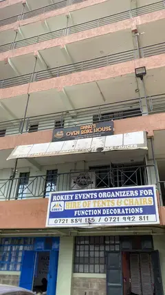
Anna’s Oven
52 m from the route · send or collect parcels here
2.2 km
0.7 km gap in the map. Stops either side are in the right order; the distance across the gap is not exact.
ILRI/Uthiru Roundabout
3.3 km
Change here for
3U/3 30 046P 103
Nearest served area: Kiambu Uthiru
Uthiru Roundabout
3.3 km
Change here for
3U/3 30 046P 103
Nearest served area: Kiambu Uthiru
St. Joseph's Kabete
3.5 km
Change here for
3U/3 046P 103
Nearest served area: Kamakis
9.7 km gap in the map. Stops either side are in the right order; the distance across the gap is not exact.
Kenyatta National Hospital
13.4 km
Change here for
2 4 4W 8 and 8 more 16 24 24C 32A 33NG 34L 102 111
13.5 km–13.8 km · 3 stages
Nearest served area: Kamakis
KNH/KMTC
13.5 km
Change here for
2 4 4W 8 and 6 more 16 32A 33NG 34L 102 111
Kenyatta National Hospital
13.5 km
Change here for
2 4 4W 8 and 6 more 16 32A 33NG 34L 102 111
Nairobi Area Traffic Police Headquarters
13.8 km
Change here for
2 4 4W 8 and 4 more 32A 33NG 102 111
15.5 km–17.5 km · 6 stages
Nearest served area: Kamakis
1.1 km gap in the map. Stops either side are in the right order; the distance across the gap is not exact.
Agip
15.5 km
Change here for
2 4 8 12D and 8 more 14A 14B 15 16 24 33B 33C 33IMR
Times Tower
15.7 km
Change here for
4 33FED
Railway Stage
16.5 km
Change here for
2 4 8 56 and 4 more 102 111 125 126
Railways
16.5 km
Change here for
2 4 8 56 and 4 more 102 111 125 126
Railways
16.9 km
Change here for
4 33C
Kenya Polytechnic Bus Stop
17.5 km
Change here for
2 4 8 12D and 8 more 14A 14B 15 16 24 33B 33C 33IMR
19.2 km–25.6 km · 11 stages
Nearest served area: Kilimani
Show the 11 stagesNHIF, Library, Nairobi Area Traffic Police Headquarters and 8 more NHIF 19.2 km Library 20.0 km Nairobi Area Traffic Police Headquarters 20.4 km KMTC Bus Stop 20.7 km Prestige 22.5 km Prestige/Number Nane 24.5 km Bishop Magua Center 24.7 km Bishop Magua Centre 24.8 km Uchumi 25.0 km China Centre 25.4 km Coptic/Mimosa 25.6 km
26.6 km–27.8 km · 6 stages
Nearest served area: Kilimani
Coptic/Mimosa
26.6 km
Change here for
2 4 4W 8 and 5 more 24 24C 32A 102 111
Uchumi/National Oil
27.2 km
Change here for
2 4 4W 8 and 4 more 24C 32A 102 111
Good Shephard
27.6 km
Change here for
2 4 8 24 and 3 more 32A 102 111
Total Ngong Road
27.6 km
Change here for
2 4 5 8 and 4 more 24 32A 102 111
Nakumatt Prestige
27.8 km
Change here for
2 4 4W 5 and 4 more 24C 32A 102 111
Prestige Plaza
27.8 km
Change here for
2 4 4W 5 and 4 more 24C 32A 102 111
28.2 km–30.0 km · 12 stages
Nearest served area: Kilimani
Show the 12 stagesMotherland, Kirichwa Road Junction, Kirichwa Road and 9 more Motherland 28.2 km Kirichwa Road Junction 28.4 km Kirichwa Road 28.4 km Adams Arcade 28.5 km Motherland 28.5 km Adam's Arcade 28.5 km Adams 28.6 km Adams Arcade 28.6 km Edulink International College 29.4 km Ndemi bus stop 29.5 km Posta/Ole Odume Road 29.8 km Marsabit Plaza 30.0 km
30.1 km–30.6 km · 5 stages
Nearest served area: Jamuhuri
Posta Stage
30.1 km
Change here for
2 4 4W 24C and 2 more 102 111
Moveka Station
Mira laundromat
443 m from the route · send or collect parcels here
30.1 km
Swedish School Nairobi
30.4 km
Change here for
2 4 4W 5 and 4 more 24 24C 102 111
Impala
30.4 km
Change here for
2 4 4W 5 and 4 more 24 24C 102 111
Impala/Swedish School Nairobi
30.4 km
Change here for
2 4 4W 5 and 4 more 24 24C 102 111
Jamuhuri/Kibera Station Road
30.6 km
Change here for
2 4 4W 5 and 3 more 24C 102 111
30.7 km–30.8 km · 3 stages
Nearest served area: Jamuhuri
Ngong Road
30.7 km
Change here for
2 4 4W 5 and 3 more 24C 102 111
Jamhuri
30.7 km
Change here for
2 4 4W 5 and 3 more 24C 102 111
Brew Bistro
30.8 km
Change here for
2 4 4W 24 and 2 more 102 111
Nearest served area: Jamuhuri
Corner/Meteorological Department/Total
31.5 km
Change here for
4 24 24C 111
Nearest served area: Jamuhuri
Corner/Meteorological Department
31.5 km
Change here for
4 24 24C 111
31.8 km–33.2 km · 8 stages
Nearest served area: Jamuhuri
Kenol Dagoretti Corner
31.8 km
Change here for
2 3U/3 4 4W and 2 more 102 103
Junction
32.1 km
Change here for
2 4 4W 24 and 3 more 24C 102 111
Dagoretti Corner Stage
32.7 km
Change here for
2 3U/3 4 4W and 2 more 102 103
Tea Board/Dagoretti Corner
32.9 km
Change here for
2 3U/3 4 4W and 2 more 102 103
40
33.0 km
Change here for
2 3U/3 4 4W and 2 more 102 103
Kaberia Junction/Wanyee Stage
33.1 km
Change here for
2 3U/3 4 4W and 2 more 102 103
Wanyee
33.1 km
Change here for
2 3U/3 4 4W and 2 more 102 103
Riara
33.2 km
Change here for
2 3U/3 4 102 and 1 more 103
33.4 km–33.4 km · 2 stages
Nearest served area: Amboseli (Lavington Area)
Melchizedek Hospital
33.4 km
Change here for
2 3U/3 4 103
Melchizedek
33.4 km
Change here for
2 3U/3 4 103
Kanisani
33.6 km
Change here for
4 103
Deliverance Church Riruta
33.8 km
Change here for
2 3U/3 4 102 and 1 more 103
33.9 km–34.2 km · 2 stages
Nearest served area: Amboseli (Lavington Area)
Riverlands
33.9 km
Change here for
2 3U/3 4 102 and 1 more 103
Midhill
34.2 km
Change here for
2 3U/3 4 102 and 1 more 103
34.3 km–35.3 km · 13 stages
Nearest served area: Amboseli (Lavington Area)
Show the 13 stagesKinyanjui, Kinangiti, Sugoini and 10 more Kinyanjui 34.3 km Kinangiti 34.4 km Sugoini 34.5 km Shimonne 34.7 km Mlangosoko 34.9 km Kawangware 35.0 km BP 35.1 km Bidii 35.2 km Kawangware 35.2 km 46 AP Camp 35.3 km Dagoretti CDF/APs' Camp 35.3 km Kwa Mbao 35.3 km AP Camp Dangoretti 35.3 km
35.4 km–35.6 km · 4 stages
Nearest served area: Amboseli (Lavington Area)
Riruta Stage
35.4 km
Change here for
2 3U/3 046P 102 and 1 more 103
Precious Blood Girls' School
35.4 km
Change here for
2 3U/3 046P 102 and 1 more 103
Precious Blood Girls Riruta
35.6 km
Change here for
2 3U/3 046P 102 and 1 more 103
Precious Girls' High School
35.6 km
Change here for
2 3U/3 046P 102 and 1 more 103
35.6 km–35.6 km · 5 stages
Nearest served area: Mountain view
Precious Blood Girls' School
35.6 km
Change here for
2 3U/3 046P 102 and 1 more 103
Krep/Equity/sidia
35.6 km
Change here for
2 3U/3 046P 102 and 1 more 103
Sidia/Equity
35.6 km
Change here for
2 3U/3 046P 102 and 1 more 103
KREP/Equity Bank
35.6 km
Change here for
2 3U/3 046P 102 and 1 more 103
Krep/Equity/Kwa Mumbi
35.6 km
Change here for
2 3U/3 046P 102 and 1 more 103
35.7 km–35.9 km · 4 stages
Nearest served area: Mountain view
Equity/Kwa Mumbi
35.7 km
Change here for
2 3U/3 046P 102 and 1 more 103
Krep/Equity
35.8 km
Change here for
3U/3 103
Ruasare
35.9 km
Change here for
3U/3 046P 103
Oilibya
35.9 km
Change here for
3U/3 046P 103
35.9 km–35.9 km · 2 stages
Nearest served area: Mountain view
Naivasha/Naivasha Road Flat
35.9 km
Change here for
3U/3 046P 103
St. John College
35.9 km
Change here for
3U/3 046P 103
35.9 km–36.0 km · 3 stages
Nearest served area: Mountain view
Muslim
35.9 km
Change here for
3U/3 046P 103
St. John College Riruta
36.0 km
Change here for
3U/3 046P 103
St. John College
36.0 km
Change here for
3U/3 046P 103
36.1 km–36.3 km · 2 stages
Nearest served area: Mountain view
Kanjerere
36.1 km
Change here for
103
Ndwaro
36.3 km
Change here for
3U/3 046P 103
36.3 km–36.3 km · 2 stages
Nearest served area: Mountain view
Ndwaru
36.3 km
Change here for
3U/3 046P 103
Ndwaru Road
36.3 km
Change here for
3U/3 046P 103
36.5 km–36.7 km · 3 stages
Nearest served area: Mountain view
Riverside Flats
36.5 km
Change here for
3U/3 103
Riverside
36.6 km
Change here for
103
Car Wash
36.7 km
Change here for
3U/3 103
36.7 km–37.2 km · 6 stages
Nearest served area: Mountain view
River Ridge School
36.7 km
Change here for
3U/3 103
Sudan
36.8 km
Change here for
3U/3 046P 103
Kangemi Road
36.9 km
Change here for
046P 103
Sudanese
36.9 km
Change here for
046P 103
Gachangi/Darajani/Baptist Church
37.1 km
Change here for
3U/3 046P 103
Forest
37.2 km
Change here for
3U/3 046P 103
37.2 km–37.5 km · 2 stages
Nearest served area: Mountain view
Kinduri
37.2 km
Change here for
046P 103
Gathondeki
37.5 km
Change here for
3U/3 046P 103
37.6 km–39.4 km · 12 stages
Nearest served area: Kiambu Uthiru
Show the 12 stagesSummer-Rock, Kwa Mtaro, ILRI and 9 more Summer-Rock 37.6 km Kwa Mtaro 37.9 km ILRI 38.4 km Iranda 38.5 km Roundabout 38.6 km Gacwiri` 38.8 km Uthiru Roundabout 38.8 km Uthiru Shopping Center 38.9 km Uthiru 39.0 km Kwa Mchanga/Total 39.1 km Uthiru Pentecostal 39.3 km Waiyaki Way/Uthiru Junction 39.4 km
39.4 km–39.5 km · 3 stages
Nearest served area: Kiambu Uthiru
Kanisa/Kwa Miti
39.4 km
Change here for
103 105 114W 115 and 1 more 135
Uthiru Junction
39.5 km
Change here for
3U/3 103 105 114W and 2 more 115 135
Uthiru
39.5 km
Change here for
3U/3 103 105 114W and 2 more 115 135
39.8 km–40.9 km · 4 stages
Nearest served area: Kiambu Uthiru
Uthiru Girls
39.8 km
Change here for
103 105 135
Deliverance Church/Kwa Miti
39.9 km
Change here for
103 105 135
Shell/Cooperation
40.2 km
Change here for
103 105 114W 115 and 1 more 135
87 Junction/Gachecheni
40.9 km
Change here for
103 105 114W 115 and 1 more 135
Nearest served area: Kiambu Uthiru
Junction
41.0 km
Change here for
103 105 114W 115 and 1 more 135
41.0 km–42.1 km · 9 stages
Nearest served area: Kiambu kinoo
Show the 9 stages87 - Junction /Gachecheni, 87, 87 - Stage/Total and 6 more 87 - Junction /Gachecheni 41.0 km 87 41.2 km 87 - Stage/Total 41.3 km 87 41.3 km Mama Ngina 41.5 km Kinoo 41.7 km Kinoo Girls High School 41.8 km Kinoo 41.9 km Kinoo Bus stop 42.1 km End Nairobi central Station 42.1 km
Moveka Stations on this route
Drop off or collect a parcel at a shop on the line.
Anna’s Oven 52 m from the route · 2.2 km along · near Wamete/Kanisani
Mira laundromat 443 m from the route · 30.1 km along · near Posta Stage
Ready to send? Parcels travel route 3 too. Send from a Station on the line.
Send a package
Map data © OpenStreetMap contributors .