Explore Moveka

Matatu route

33MKR

St. BakhitaBus Station

About 15 km between St. Bakhita and Bus Station, through South C, Nairobi West, Woodley/Kenyatta/Golf Course. 2 Moveka Stations are on or beside the line.

St. BakhitaBus Station2 km © OpenStreetMap contributors

The route at a glance

15 km through 5 sections, drawn to scale. Select a section to jump to its stops.

Route 33MKR at a glanceOverview of route 33MKR from St. Bakhita to Bus Station: 15 km through 5 sections, with 16 stages, 9 change points and Moveka Stations beside 2 stages. The ordered list below gives the same information in text.Imara Daima, 0.0 to 1.1 km, 4 stagesImara DaimaSouth C, 5.7 to 10.7 km, 8 stagesSouth CNairobi West, 11.7 to 11.7 km, 1 stageNairobi WestWoodley/Kenyatta/Golf Course, 12.7 to 12.7 km, 1 stageWoodley/Kenyatta/G…Starehe, 13.7 to 15.0 km, 2 stagesStareheSt. Bakhita · 0 kmBus Station · 15 km
Route 33MKR at a glanceOverview of route 33MKR from St. Bakhita to Bus Station: 15 km through 5 sections, with 16 stages, 9 change points and Moveka Stations beside 2 stages. The ordered list below gives the same information in text.Imara Daima, 0.0 to 1.1 km, 4 stagesImara DaimaSouth C, 5.7 to 10.7 km, 8 stagesSouth CNairobi West, 11.7 to 11.7 km, 1 stageNairobi WestWoodley/Kenyatta/Golf Course, 12.7 to 12.7 km, 1 stageStarehe, 13.7 to 15.0 km, 2 stagesStareheSt. Bakhita · 0 kmBus Station · 15 km

Stops from St. Bakhita to Bus Station

Show Bus Station to St. Bakhita
  1. Start
    St. Bakhita
    0.0 km
  2. Imara Daima

    0.0 km–1.1 km · 4 stages

    Nearest served area: Imara Daima

  3. St. Bakhita

    0.0 km
  4. AA

    0.5 km
  5. Maziwa

    0.6 km
  6. Imara Daima

    1.1 km

    Change here for 33IMR

  7. Moveka Station

    Imara Carpets

    151 m from the route · send or collect parcels here

    1.1 km
  8. South C

    5.7 km–10.7 km · 8 stages

    Nearest served area: South B

  9. 4.6 km to the next stage
  10. GM

    5.7 km

    Change here for 33B33C33FED33IMR

    and 4 more33TP33UTW110110ATH

  11. Sameer

    6.3 km

    Change here for 33B33C33IMR33TP

    and 3 more33UTW110110ATH

  12. Bobmill

    6.9 km

    Change here for 33B33C33FED33IMR

    and 4 more33TP33UTW110110ATH

  13. Panari

    7.4 km

    Change here for 33B33C33FED33IMR

    and 4 more33TP33UTW110110ATH

  14. Airtel

    8.3 km

    Change here for 33B33C33FED33IMR

    and 4 more33TP33UTW110110ATH

  15. Shell

    9.2 km

    Change here for 33B33C33IMR33TP

    and 3 more33UTW110110ATH

  16. Belleview

    9.7 km

    Change here for 12C12D33B33C

    and 5 more33FED33IMR33UTW110110ATH

  17. South C Shopping Centre

    10.7 km

    Change here for 12C33C33UTW

  18. Nairobi West

    11.7 km · 1 stage

    Nearest served area: Nairobi West

  19. Nyayo

    11.7 km

    Change here for 12C12D33B33C

    and 6 more33FED33IMR33TP33UTW110110ATH

  20. Moveka Station

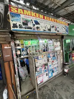
    Samken Electronics

    433 m from the route · send or collect parcels here

    11.7 km
  21. Woodley/Kenyatta/Golf Course

    12.7 km · 1 stage

    Nearest served area: Nairobi West

  22. Makaburini

    12.7 km

    Change here for 12C14A14B15

    and 8 more33B33C33FED33IMR33UTW110110ATH125

  23. Starehe

    13.7 km–15.0 km · 2 stages

    Nearest served area: Kamakis

  24. Agip

    13.7 km

    Change here for 2348

    and 8 more12D14A14B15162433B33C

  25. Bus Station

    15.0 km

    Change here for 1111_212C12D

    and 5 more14A14B151643

  26. End
    Bus Station
    15.0 km

Ready to send?

Parcels travel route 33MKR too. Send from a Station on the line.

Send a package

Stops from Approved SACCOs - University of Nairobi C4D Lab reporting/sharing, service 2019 to 2020. Map data © OpenStreetMap contributors.