Explore Moveka

Matatu route

17B

MwikiBus Station

About 17 km between Mwiki and Bus Station, through Clay City, Kasarani, Utalii, Hospital. 6 Moveka Stations are on or beside the line.

MwikiBus Station2 km © OpenStreetMap contributors

The route at a glance

17 km through 9 sections, drawn to scale. Select a section to jump to its stops.

Route 17B at a glanceOverview of route 17B from Mwiki to Bus Station: 17 km through 9 sections, with 34 stages, 8 change points and Moveka Stations beside 6 stages. The ordered list below gives the same information in text.Mwiki, 0.0 to 0.2 km, 2 stagesMwikiClay City, 0.5 to 1.2 km, 4 stagesClay CityKasarani, 1.6 to 7.7 km, 19 stagesKasaraniUtalii, 9.3 to 11.0 km, 4 stagesUtaliiHospital, 12.4 to 12.4 km, 1 stageHospitalStarehe, 13.2 to 13.2 km, 1 stageStareheZiwani/Kariokor, 15.4 to 15.4 km, 1 stageZiwani/KariokorKamukunji, 16.2 to 16.2 km, 1 stageKamukunjiStarehe, 16.6 to 16.6 km, 1 stageMwiki · 0 kmBus Station · 17 km
Route 17B at a glanceOverview of route 17B from Mwiki to Bus Station: 17 km through 9 sections, with 34 stages, 8 change points and Moveka Stations beside 6 stages. The ordered list below gives the same information in text.Mwiki, 0.0 to 0.2 km, 2 stagesMwikiClay City, 0.5 to 1.2 km, 4 stagesKasarani, 1.6 to 7.7 km, 19 stagesKasaraniUtalii, 9.3 to 11.0 km, 4 stagesUtaliiHospital, 12.4 to 12.4 km, 1 stageHospitalStarehe, 13.2 to 13.2 km, 1 stageStareheZiwani/Kariokor, 15.4 to 15.4 km, 1 stageKamukunji, 16.2 to 16.2 km, 1 stageKamukunjiStarehe, 16.6 to 16.6 km, 1 stage2Mwiki · 0 kmBus Station · 17 km

Stops from Mwiki to Bus Station

Show Bus Station to Mwiki
  1. Start
    Mwiki
    0.0 km
  2. Mwiki

    0.0 km–0.2 km · 2 stages

    Nearest served area: Mwiki

  3. Mwiki

    0.0 km

    Change here for 17B_2

  4. Kwa Mlima

    0.2 km

    Change here for 17B_2

  5. Clay City

    0.5 km–1.2 km · 4 stages

    Nearest served area: Kasarani sunton

  6. Maji Mazuri

    0.5 km

    Change here for 17B_2

  7. Garage

    0.7 km

    Change here for 17B_2

  8. Kamutiini

    0.9 km

    Change here for 17B_2

  9. Sunton

    1.2 km

    Change here for 17B_249

  10. Kasarani

    1.6 km–7.7 km · 19 stages

    Nearest served area: Kasarani Seasons

  11. Show the 19 stagesHunters, St. Francis, Ngorofani and 16 more
    • Hunters1.6 km
    • St. Francis1.8 km
    • Ngorofani2.0 km
    • Maternity2.4 km
    • Stima2.8 km
    • Kwa Wachina3.0 km
    • Kasarani Primary3.4 km
    • Police Post3.6 km
    • Seasons3.7 km
    • Equity4.0 km
    • Corner4.2 km
    • Bull and Bush4.3 km
    • Naivas4.5 km
    • Regional/ICIPE4.8 km
    • TRM5.1 km
    • Stadium5.3 km
    • Safari Park6.0 km
    • Garden City/Homeland Inn6.9 km
    • Roasters7.7 km
  12. Moveka Station

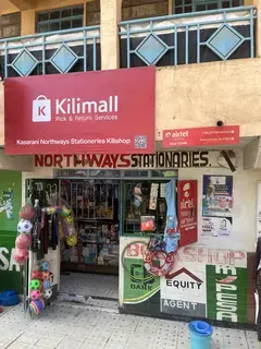
    Northways Stationeries

    149 m from the route · send or collect parcels here

    1.6 km
  13. Moveka Station

    Pinky rosy salon

    224 m from the route · send or collect parcels here

    3.7 km
  14. Moveka Station

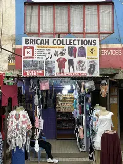
    Bricah Collections

    35 m from the route · send or collect parcels here

    4.0 km
  15. Moveka Station

    Nosh gamers Trm

    232 m from the route · send or collect parcels here

    5.3 km
  16. Moveka Station

    Maxed auto

    374 m from the route · send or collect parcels here

    7.7 km
  17. Utalii

    9.3 km–11.0 km · 4 stages

    Nearest served area: Allsops

  18. 1.6 km to the next stage
  19. Allsops

    9.3 km

    Change here for 2525A2743

    and 7 more44G44Z45G45K49145237

  20. Drive In

    9.8 km

    Change here for 2525A2729/30

    and 8 more4344G44Z45G45K49145237

  21. KCA/Survey

    10.5 km

    Change here for 2525A2729/30

    and 8 more4344G44Z45G45K49145237

  22. Utalii

    11.0 km

    Change here for 2525A2729/30

    and 8 more4344G44Z45G45K49145237

  23. Hospital

    12.4 km · 1 stage

    Nearest served area: Eastleigh

  24. Muthaiga

    12.4 km

    Change here for 2525A2729/30

    and 8 more4344G44Z45G45K49145237

  25. Starehe

    13.2 km · 1 stage

    Nearest served area: Eastleigh

  26. Pangani/Muthaiga Footbridge

    13.2 km

    Change here for 11C2525A27

    and 8 more29/304344G44Z45G45K49100

  27. Ziwani/Kariokor

    15.4 km · 1 stage

    Nearest served area: Kenol

  28. 2.2 km to the next stage
  29. Kariokor

    15.4 km

    Change here for 3N71416/62

    and 8 more2732D4345G46B46H120121

  30. Kamukunji

    16.2 km · 1 stage

    Nearest served area: Kamkunji

  31. Muthurwa

    16.2 km

    Change here for 2743

  32. Moveka Station

    Aura Collections

    246 m from the route · send or collect parcels here

    16.2 km
  33. Starehe

    16.6 km · 1 stage

    Nearest served area: Kamkunji

  34. Bus Station

    16.6 km

    Change here for 1533NG43

  35. End
    Bus Station
    16.6 km

Ready to send?

Parcels travel route 17B too. Send from a Station on the line.

Send a package

Stops from Approved SACCOs - University of Nairobi C4D Lab reporting/sharing, service 2019 to 2020. Map data © OpenStreetMap contributors.