Explore Moveka

Matatu route

100

Kiambu Bus TerminusOTC

About 16 km between Kiambu Bus Terminus and OTC, through Roysambu, Highridge, Starehe. 4 Moveka Stations are on or beside the line.

Kiambu Bus TerminusOTC2 km © OpenStreetMap contributors

The route at a glance

16 km through 9 sections, drawn to scale. Select a section to jump to its stops.

Route 100 at a glanceOverview of route 100 from Kiambu Bus Terminus to OTC: 16 km through 9 sections, with 37 stages, 2 change points and Moveka Stations beside 4 stages. The ordered list below gives the same information in text.Kiambu Township, 0.0 to 5.9 km, 16 stagesKiambu TownshipRoysambu, 6.3 to 8.3 km, 7 stagesRoysambuHighridge, 8.7 to 8.9 km, 2 stagesHighridgeRoysambu, 9.0 to 10.1 km, 4 stagesRoysambuHighridge, 11.3 to 12.0 km, 2 stagesHighridgeRoysambu, 12.2 to 12.3 km, 2 stagesRoysambuStarehe, 13.2 to 13.2 km, 1 stageStareheNgara, 14.1 to 14.9 km, 2 stagesNgaraStarehe, 16.1 to 16.1 km, 1 stageStareheKiambu Bus Terminus · 0 kmOTC · 16 km
Route 100 at a glanceOverview of route 100 from Kiambu Bus Terminus to OTC: 16 km through 9 sections, with 37 stages, 2 change points and Moveka Stations beside 4 stages. The ordered list below gives the same information in text.Kiambu Township, 0.0 to 5.9 km, 16 stagesKiambu Towns…Roysambu, 6.3 to 8.3 km, 7 stagesRoysambuHighridge, 8.7 to 8.9 km, 2 stagesHighridgeRoysambu, 9.0 to 10.1 km, 4 stagesHighridge, 11.3 to 12.0 km, 2 stagesHighridgeRoysambu, 12.2 to 12.3 km, 2 stagesRoysambuStarehe, 13.2 to 13.2 km, 1 stageNgara, 14.1 to 14.9 km, 2 stagesNgaraStarehe, 16.1 to 16.1 km, 1 stageStareheKiambu Bus Termi… · 0 kmOTC · 16 km

Stops from Kiambu Bus Terminus to OTC

Show OTC to Kiambu Bus Terminus
  1. Start
    Kiambu Bus Terminus
    0.0 km
  2. Kiambu Township

    0.0 km–5.9 km · 16 stages

    Nearest served area: Kasarini thindigua kiambu

  3. Show the 16 stagesKiambu Bus Terminus, Old Kiambu, Kwa Ahindi and 13 more
    • Kiambu Bus Terminus0.0 km
    • Old Kiambu1.0 km
    • Kwa Ahindi1.1 km
    • Total Kiambu1.4 km
    • Kwa DO/Kiambu-Limuru Junction2.0 km
    • Kirigiti/Ruui2.6 km
    • KIST3.1 km
    • Itara3.3 km
    • Kwa Ng'ethe/Fivestar3.8 km
    • Barua4.2 km
    • Mushroom4.5 km
    • Thindigwa5.1 km
    • Kasarini5.3 km
    • Quickmart5.4 km
    • Diamond Flats5.6 km
    • Kasarini/Paradise Lost5.9 km
  4. Moveka Station

    Phyka gift shop kiambu town

    62 m from the route · send or collect parcels here

    0.0 km
  5. Moveka Station

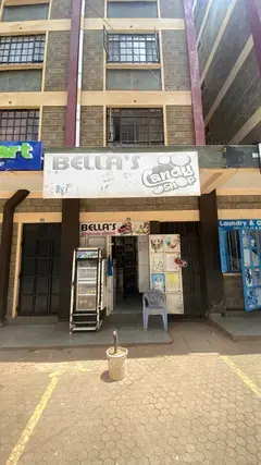
    Bellas candy shop

    119 m from the route · send or collect parcels here

    5.6 km
  6. Roysambu

    6.3 km–8.3 km · 7 stages

    Nearest served area: Four-ways Kiambu road

  7. Evergreen

    6.3 km

    Change here for 120

  8. Balkan Sec School

    6.6 km

    Change here for 100A120121

  9. Moveka Station

    Missyz collection kiambu road

    183 m from the route · send or collect parcels here

    6.6 km
  10. Bypass/Kwaheri Flyover

    7.0 km

    Change here for 100A107D120121

  11. Githogoro/Kigwa

    7.4 km

    Change here for 100A120121

  12. Runda Junction

    7.7 km

    Change here for 100A120121

  13. Ridgeviews

    8.0 km
  14. Naivas Ciata Mall/Ridgeways Mall

    8.3 km

    Change here for 100A120121

  15. Highridge

    8.7 km–8.9 km · 2 stages

    Nearest served area: Four-ways Kiambu road

  16. Ridgeway Springs

    8.7 km

    Change here for 100A120121

  17. Jikoni's

    8.9 km

    Change here for 100A120

  18. Roysambu

    9.0 km–10.1 km · 4 stages

    Nearest served area: Four-ways Kiambu road

  19. Wanderjoy

    9.0 km

    Change here for 100A120121

  20. JCL Motors

    9.5 km

    Change here for 100A120

  21. Rock City

    9.8 km

    Change here for 100A120121

  22. Shark's Palace

    10.1 km

    Change here for 100A120121

  23. Highridge

    11.3 km–12.0 km · 2 stages

    Nearest served area: Eastleigh

  24. KFS/CID

    11.3 km

    Change here for 100A120121

  25. Karura Close

    12.0 km

    Change here for 120

  26. Roysambu

    12.2 km–12.3 km · 2 stages

    Nearest served area: Eastleigh

  27. Muthaiga Golf Club Entrance

    12.2 km

    Change here for 121

  28. muthaiga Golf Club Stage

    12.3 km

    Change here for 100A120121

  29. Starehe

    13.2 km · 1 stage

    Nearest served area: Eastleigh

  30. Shell/Pangani Footbridge

    13.2 km

    Change here for 11C17B2525A

    and 8 more2729/304344G44Z45G45K49

  31. Ngara

    14.1 km–14.9 km · 2 stages

    Nearest served area: Kenol

  32. Supermambo

    14.1 km

    Change here for 6100A120

  33. TSS Petrol Station/Blue Hut Hotel

    14.9 km
  34. Starehe

    16.1 km · 1 stage

    Nearest served area: Kamkunji

  35. OTC

    16.1 km

    Change here for 71116/6217B

    and 8 more19Cdc33TP34B34J35/6039SK58120

  36. Moveka Station

    Aura Collections

    400 m from the route · send or collect parcels here

    16.1 km
  37. End
    OTC
    16.1 km

Ready to send?

Parcels travel route 100 too. Send from a Station on the line.

Send a package

Stops from Approved SACCOs - University of Nairobi C4D Lab reporting/sharing, service 2019 to 2020. Map data © OpenStreetMap contributors.