Explore Moveka

Matatu route

110ATH

Easy Coach/UchumiMakadara

About 31 km between Easy Coach/Uchumi and Makadara, through Landimawe, Nairobi South, Imara Daima, Pipeline. 3 Moveka Stations are on or beside the line.

Easy Coach/UchumiMakadara2 km © OpenStreetMap contributors

The route at a glance

31 km through 9 sections, drawn to scale. Select a section to jump to its stops.

Route 110ATH at a glanceOverview of route 110ATH from Easy Coach/Uchumi to Makadara: 31 km through 9 sections, with 39 stages, 8 change points and Moveka Stations beside 3 stages. The ordered list below gives the same information in text.Kamukunji, 0.0 to 0.0 km, 1 stageKamukunjiLandimawe, 2.6 to 3.0 km, 2 stagesNairobi South, 4.0 to 8.3 km, 6 stagesImara Daima, 8.6 to 10.5 km, 3 stagesImara DaimaPipeline, 11.6 to 12.7 km, 2 stagesPipelineSouth C, 14.0 to 14.6 km, 2 stagesSyokimau-Mulolongo, 15.1 to 21.4 km, 10 stagesSyokimau-Mul…Matathani, 22.1 to 26.2 km, 5 stagesMatathaniAthi River, 26.6 to 30.9 km, 8 stagesAthi RiverEasy Coach/Uchumi · 0 kmMakadara · 31 km

Stops from Easy Coach/Uchumi to Makadara

Show Makadara to Easy Coach/Uchumi
  1. Start
    Easy Coach/Uchumi
    0.0 km
  2. Kamukunji

    0.0 km · 1 stage

    Nearest served area: Kamkunji

  3. Easy Coach/Uchumi

    0.0 km

    Change here for 110

  4. Landimawe

    2.6 km–3.0 km · 2 stages

    Nearest served area: Nairobi West

  5. 2.6 km to the next stage
  6. Nyayo

    2.6 km

    Change here for 12C12D33B33C

    and 6 more33FED33IMR33MKR33TP33UTW110

  7. Moveka Station

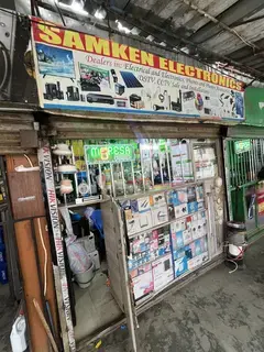
    Samken Electronics

    464 m from the route · send or collect parcels here

    2.6 km
  8. Government Plaza/Devis

    3.0 km

    Change here for 12C12D33B33C

    and 6 more33FED33IMR33MKR33TP33UTW110

  9. Nairobi South

    4.0 km–8.3 km · 6 stages

    Nearest served area: South B

  10. Capital Centre

    4.0 km

    Change here for 12C12D33B33C

    and 6 more33FED33IMR33MKR33TP33UTW110

  11. Belleview

    4.6 km

    Change here for 12C12D33B33C

    and 6 more33FED33IMR33MKR33TP33UTW110

  12. Park Side Towers/Airtel

    6.0 km

    Change here for 33B33C33FED33IMR

    and 4 more33MKR33TP33UTW110

  13. Panari

    6.8 km

    Change here for 33B33C33FED33IMR

    and 4 more33MKR33TP33UTW110

  14. Standard Group

    7.3 km

    Change here for 33B33C33FED33IMR

    and 4 more33MKR33TP33UTW110

  15. Sameer

    8.3 km

    Change here for 33B33FED33IMR33MKR

    and 3 more33TP33UTW110

  16. Imara Daima

    8.6 km–10.5 km · 3 stages

    Nearest served area: Imara Daima

  17. GM

    8.6 km

    Change here for 33B33C33FED33IMR

    and 4 more33MKR33TP33UTW110

  18. Imara Daima

    9.6 km

    Change here for 33B33C33FED33TP

    and 2 more33UTW110

  19. Cabanas

    10.5 km

    Change here for 33FED33TP

  20. Pipeline

    11.6 km–12.7 km · 2 stages

    Nearest served area: Imara Daima

  21. Tuffsteel

    11.6 km

    Change here for 110

  22. Airport Junction

    12.7 km

    Change here for 110

  23. South C

    14.0 km–14.6 km · 2 stages

    Nearest served area: Syokimau (Gateway Mall)

  24. Nice N Lovely

    14.0 km

    Change here for 110

  25. SGR

    14.6 km

    Change here for 110

  26. Syokimau-Mulolongo

    15.1 km–21.4 km · 10 stages

    Nearest served area: Mlolongo

  27. Show the 10 stagesKapa, Mabati, Nation and 7 more
    • Kapa15.1 km
    • Mabati16.1 km
    • Nation16.7 km
    • Syokimau17.7 km
    • Allpack18.3 km
    • Tops/Stage Ya Juu19.4 km
    • Mlolongo19.8 km
    • Petma/Mlolongo Chini20.1 km
    • Kasina20.7 km
    • Mjengo21.4 km
  28. Moveka Station

    Lighthouse Aquarium

    164 m from the route · send or collect parcels here

    15.1 km
  29. Moveka Station

    Spartans Games Crib Mlolongo

    252 m from the route · send or collect parcels here

    19.4 km
  30. Matathani

    22.1 km–26.3 km · 5 stages

    Nearest served area: Mlolongo

  31. Kenchic

    22.1 km

    Change here for 110

  32. Sabaki

    23.1 km

    Change here for 110

  33. Toll

    24.0 km

    Change here for 110

  34. 1.7 km to the next stage
  35. Namanga Junction

    25.7 km
  36. Everest

    26.3 km
  37. Athi River

    26.6 km–30.9 km · 8 stages

    Nearest served area: Kitengela

  38. 39

    26.6 km
  39. Devki

    28.1 km

    Change here for 110AK

  40. KMTC

    28.5 km

    Change here for 110AK

  41. Sokoni/Peponi

    29.2 km

    Change here for 110AK

  42. KMC

    29.7 km

    Change here for 110AK

  43. Starsheik

    30.1 km

    Change here for 110AK

  44. Sulami/Nyambura

    30.3 km

    Change here for 110AK

  45. Makadara

    30.9 km

    Change here for 110AK

  46. End
    Makadara
    30.9 km

Ready to send?

Parcels travel route 110ATH too. Send from a Station on the line.

Send a package

Stops from Approved SACCOs - University of Nairobi C4D Lab reporting/sharing, service 2019 to 2020. Map data © OpenStreetMap contributors.