Explore Moveka

Matatu route

126RK

Kiserain Nairobi Bus StopSoronik Road

About 10 km between Kiserain Nairobi Bus Stop and Soronik Road, through Olkeri, Nkaimurunya. 6 Moveka Stations are on or beside the line.

Kiserain Nairobi Bus StopSoronik Road2 km © OpenStreetMap contributors

The route at a glance

10 km through 4 sections, drawn to scale. Select a section to jump to its stops.

Route 126RK at a glanceOverview of route 126RK from Kiserain Nairobi Bus Stop to Soronik Road: 10 km through 4 sections, with 36 stages, 0 change points and Moveka Stations beside 4 stages. The ordered list below gives the same information in text.Keekonyokie, 0.0 to 0.0 km, 1 stageKeekonyokieOlkeri, 0.2 to 6.0 km, 20 stagesOlkeriNkaimurunya, 6.6 to 9.2 km, 13 stagesNkaimurunyaOngata Rongai, 9.8 to 10.0 km, 2 stagesOngata Rongai22Kiserain Nairobi Bus Stop · 0 kmSoronik Road · 10 km
Route 126RK at a glanceOverview of route 126RK from Kiserain Nairobi Bus Stop to Soronik Road: 10 km through 4 sections, with 36 stages, 0 change points and Moveka Stations beside 4 stages. The ordered list below gives the same information in text.Keekonyokie, 0.0 to 0.0 km, 1 stageKeekonyokieOlkeri, 0.2 to 6.0 km, 20 stagesOlkeriNkaimurunya, 6.6 to 9.2 km, 13 stagesNkaimurunyaOngata Rongai, 9.8 to 10.0 km, 2 stagesOngata Rongai23Kiserain Nairobi… · 0 kmSoronik Road · 10 km

Stops from Kiserain Nairobi Bus Stop to Soronik Road

Show Soronik Road to Kiserain Nairobi Bus Stop
  1. Start
    Kiserain Nairobi Bus Stop
    0.0 km
  2. Keekonyokie

    0.0 km · 1 stage

    Nearest served area: Kiserian

  3. Kiserain Nairobi Bus Stop

    0.0 km
  4. Olkeri

    0.2 km–6.0 km · 20 stages

    Nearest served area: Kiserian

  5. Show the 20 stagesKiserian, Triangle, Gichagi and 17 more
    • Kiserian0.2 km
    • Triangle0.9 km
    • Gichagi1.2 km
    • Olenana1.3 km
    • Kwa Maji1.5 km
    • Kahungo1.9 km
    • Horse Man2.1 km
    • Nyati2.4 km
    • Kwa Rachel2.4 km
    • Nalepo2.5 km
    • Kwa Ratio2.6 km
    • Mashuria2.8 km
    • Rimpa Road3.2 km
    • Kwa Njenga3.5 km
    • Kamura4.1 km
    • Kanisani4.5 km
    • Flats/Arap Moi4.8 km
    • White House5.1 km
    • Barabara Mpya/Adventist University5.6 km
    • Acacia6.0 km
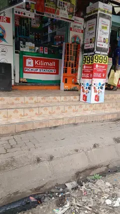
  6. Moveka Station

    Xtreme media Kiserian

    28 m from the route · send or collect parcels here

    1.2 km
  7. Nkaimurunya

    6.6 km–9.2 km · 13 stages

    Nearest served area: Rongai

  8. Show the 13 stagesMagacia, Exciting, Kwa Kimani/Laiser Hill and 10 more
    • Magacia6.6 km
    • Exciting6.9 km
    • Kwa Kimani/Laiser Hill7.1 km
    • Baptist Church7.3 km
    • Caltex/Total7.5 km
    • Millenium7.7 km
    • Places/Chap Chap7.9 km
    • Olerai8.2 km
    • Fatima8.3 km
    • Nairobi Women's Hospital8.4 km
    • Fair Mart8.7 km
    • Kware8.8 km
    • Tuskys9.2 km
  9. Moveka Station

    Xtreme media Tuskys

    75 m from the route · send or collect parcels here

    9.2 km
  10. Moveka Station

    Xtreme media Gataka

    211 m from the route · send or collect parcels here

    9.2 km
  11. Ongata Rongai

    9.8 km–10.0 km · 2 stages

    Nearest served area: Rongai

  12. Nyotu

    9.8 km

    Change here for 125126

  13. Moveka Station

    5th Avenue extreme media

    194 m from the route · send or collect parcels here

    9.8 km
  14. Soronik Road

    10.0 km

    Change here for 125126

  15. 2 Moveka Stations

    Together here · send or collect parcels at any of them

    10.0 km
  16. End
    Soronik Road
    10.0 km

Ready to send?

Parcels travel route 126RK too. Send from a Station on the line.

Send a package

Stops from Approved SACCOs - University of Nairobi C4D Lab reporting/sharing, service 2019 to 2020. Map data © OpenStreetMap contributors.